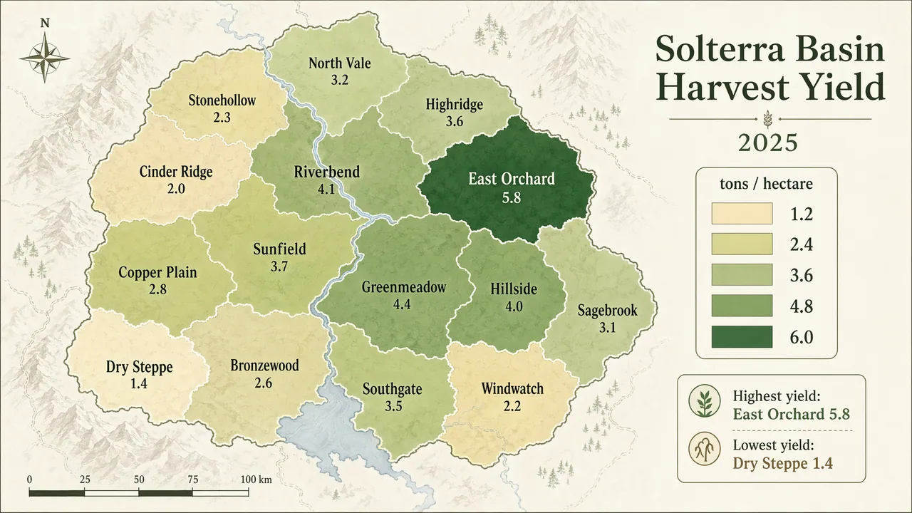
Produce a polished geographic choropleth map infographic of a fictional agricultural region called the Solterra Basin, showing harvest yield by district. Use a minimalist cartographic style on an off-white background with muted terrain hints and a sequential palette from pale sand to deep green. The map should include 14 clearly separated districts with clean borders, crisp labels, and a right-side legend. Include in-image text: "Solterra Basin Harvest Yield", "2025", and legend title "tons / hectare". Label districts with names such as "North Vale", "Riverbend", "Copper Plain", "East Orchard", and "Cinder Ridge". Include legend values "1.2", "2.4", "3.6", "4.8", and "6.0". Add a compact annotation box reading "Highest yield: East Orchard 5.8" and "Lowest yield: Dry Steppe 1.4". Prioritize clean typography, accurate map-like geometry, balanced composition, subtle cartographic detail, and publication-grade infographic clarity.
한국어 번역
솔테라 분지(Solterra Basin)라는 가상 농업 지역의 지역구별 수확량을 보여주는 세련된 지리적 단계구분도 인포그래픽을 제작하라. 미색 배경에 절제된 지형 암시를 넣은 미니멀한 지도 제작 스타일과 옅은 모래색에서 짙은 녹색으로 이어지는 순차 팔레트를 사용한다. 지도에는 깔끔한 경계, 선명한 라벨, 오른쪽 범례를 갖춘 14개의 명확히 구분된 지역구가 포함되어야 한다. 이미지 내 텍스트 "Solterra Basin Harvest Yield", "2025", 범례 제목 "tons / hectare"를 포함한다. 지역구에는 "North Vale", "Riverbend", "Copper Plain", "East Orchard", "Cinder Ridge" 같은 이름을 표기한다. 범례 값 "1.2", "2.4", "3.6", "4.8", "6.0"을 포함한다. "Highest yield: East Orchard 5.8"과 "Lowest yield: Dry Steppe 1.4"를 읽는 간결한 주석 상자를 추가한다. 깔끔한 타이포그래피, 정확한 지도형 기하학, 균형 잡힌 구도, 은은한 지도 제작 디테일, 출판 수준의 인포그래픽 명료성을 우선한다.