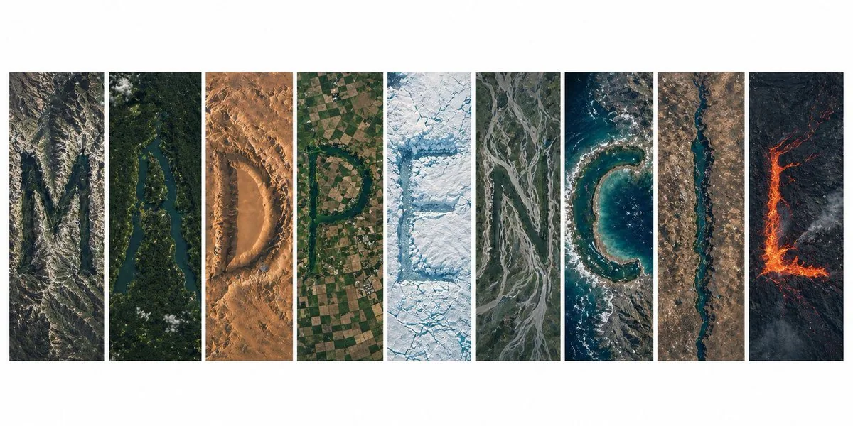
Ultra-realistic overhead satellite view from orbit, a crisp modern editorial layout featuring 9 vertical panels arranged side by side on a white background, together spelling "MADPENCIL", each panel containing a single letter formed entirely from real Earth terrain and natural topography, no text overlays:

Panel 1 (M): jagged mountain ridges and deep ravines composing a sharp angular "M", dramatic shadows, rocky surface
Panel 2 (A): a meandering river through thick tropical forest shaping an "A", vivid contrast between water and canopy
Panel 3 (D): vast desert sand dunes sculpted by wind into a smooth "D", warm earthy tones, gentle gradients
Panel 4 (P): patchwork cropland and geometric farm fields arranged into a structured "P", clean grid patterns
Panel 5 (E): glacial formations and ice sheets carving a crisp "E", pure whites and deep icy blues, cracked textures
Panel 6 (N): a braided floodplain river system forming "N", branching channels and natural flow patterns
Panel 7 (C): a curved coastline and ocean meeting point shaping "C", wave breaks and sediment visible
Panel 8 (I): a narrow slot canyon or straight waterway forming a minimal "I", strong vertical line
Panel 9 (L): volcanic landscape with hardened lava flows forming an "L", dark basalt with glowing lava accents

straight-down satellite perspective, NASA Earth imagery aesthetic, hyper-detailed terrain, realistic geography, consistent lighting and scale across panels, minimal cloud cover, high contrast, sharp resolution, subtle atmospheric haze, true-color grading, ultra high resolution 8K, clean panel spacing, gallery-style composition, visually unified but each panel a distinct biome, letters legible yet organically merged with the landscape

#AIart #GPTImage2
한국어 번역
궤도에서 내려다본 초현실적 위성 뷰, 흰색 배경에 나란히 배치된 9개의 세로 패널로 구성된 선명하고 현대적인 에디토리얼 레이아웃, 전체를 합치면 "MADPENCIL"을 철자하며, 각 패널에는 실제 지구 지형과 자연 지형만으로 형성된 단일 문자가 들어 있고 텍스트 오버레이는 없습니다:

패널 1 (M): 뾰족한 산맥과 깊은 협곡이 날카로운 각진 "M"을 이루고, 극적인 그림자, 암석 표면
패널 2 (A): 울창한 열대림을 가로지르는 구불구불한 강이 "A"를 만들고, 물과 수관층의 선명한 대비
패널 3 (D): 바람이 매끄러운 "D"로 조각한 광대한 사막 모래언덕, 따뜻한 흙빛 톤, 부드러운 그라데이션
패널 4 (P): 구조화된 "P"로 배치된 이모작 경작지와 기하학적 농지, 깔끔한 격자 패턴
패널 5 (E): 빙하 지형과 빙상이 선명한 "E"를 새기고, 순수한 흰색과 깊은 얼음빛 파랑, 갈라진 질감
패널 6 (N): "N"을 이루는 망상 범람원 하천 시스템, 갈라지는 수로와 자연스러운 흐름 패턴
패널 7 (C): "C"를 만드는 굽은 해안선과 바다가 만나는 지점, 파도가 부서지고 퇴적물이 보임
패널 8 (I): 최소한의 "I"를 이루는 좁은 슬롯 협곡 또는 곧은 수로, 강한 수직선
패널 9 (L): "L"을 이루는 굳은 용암류가 있는 화산 지형, 어두운 현무암과 빛나는 용암 악센트

수직으로 내려다보는 위성 시점, NASA Earth 이미지 미학, 초정밀 지형, 사실적인 지리, 패널 전체의 일관된 조명과 스케일, 최소한의 구름, 높은 대비, 선명한 해상도, 은은한 대기 안개, 트루 컬러 그레이딩, 초고해상도 8K, 깔끔한 패널 간격, 갤러리 스타일 구성, 시각적으로 통일되어 있지만 각 패널은 뚜렷하게 다른 생물군계, 문자는 읽히면서도 지형과 유기적으로 융합

#AIart #GPTImage2