ポイント・ネモのインフォグラフィック
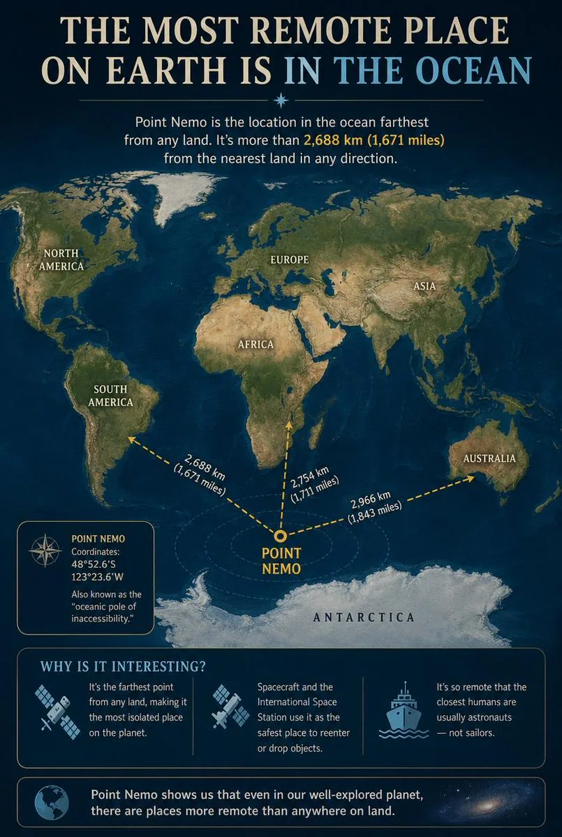
海洋の到達不能極であるポイント・ネモ(Point Nemo)を詳しく解説する教育用インフォグラフィック。各大陸に対する位置と、その隔絶ぶりに関する興味深い事実を示します。
プロンプト
Goal: Create an educational infographic explaining {argument name="topic" default="Point Nemo, the most remote place on Earth located in the ocean"}.

Canvas: Vertical portrait layout with a deep navy blue background and a subtle starry night sky texture at the top. The style is clean, modern, and informative, using gold and white text for high contrast.

Layout:
1. **Header:** Large serif title "THE MOST REMOTE PLACE ON EARTH IS IN THE OCEAN" (with "IN THE OCEAN" highlighted in light blue). Below it, a small introductory paragraph defining Point Nemo as the location farthest from land, mentioning the distance of 2,688 km (1,671 miles).
2. **Central Map:** A stylized world map centered on the South Pacific Ocean. Continents are rendered in muted earth tones (greens, browns) against dark blue oceans. Labels include NORTH AMERICA, SOUTH AMERICA, EUROPE, ASIA, AFRICA, AUSTRALIA, and ANTARCTICA.
3. **Data Visualization:** A bright yellow dot marks "POINT NEMO" in the ocean south of Easter Island. Three dashed yellow arrows radiate from this point to the nearest landmasses, labeled with distances: "2,688 km (1,671 miles)" to Antarctica, "2,754 km (1,711 miles)" to South America, and "2,966 km (1,843 miles)" to Australia.
4. **Info Box (Left):** A rectangular box with a compass icon containing the coordinates "48°52.6'S 123°23.6'W" and the nickname "oceanic pole of inaccessibility."
5. **Bottom Section:** A section titled "WHY IS IT INTERESTING?" with three columns featuring icons and text:
   - Icon: Satellite dish. Text: "It's the farthest point from any land, making it the most isolated place on the planet."
   - Icon: Space station/satellite. Text: "Spacecraft and the International Space Station use it as the safest place to reenter or drop objects."
   - Icon: Ship. Text: "It's so remote that the closest humans are usually astronauts — not sailors."
6. **Footer:** A concluding statement next to a globe icon: "Point Nemo shows us that even in our well-explored planet, there are places more remote than anywhere on land."

Visual Style: Professional infographic design. Use clear sans-serif fonts for body text and serif fonts for headings. Ensure the map projection clearly highlights the isolation of the central point.
日本語訳
目的:{argument name="topic" default="Point Nemo, the most remote place on Earth located in the ocean"} を解説する教育用インフォグラフィックを作成する。

キャンバス:縦長のポートレートレイアウトで、深いネイビーブルーの背景、上部にはさりげない星空のテクスチャ。スタイルはクリーンでモダン、情報が伝わりやすいもので、コントラストを高めるために金色と白のテキストを使用する。

レイアウト:
1. **ヘッダー:** 大きなセリフ体のタイトル "THE MOST REMOTE PLACE ON EARTH IS IN THE OCEAN"("IN THE OCEAN" は水色でハイライト)。その下に、ポイント・ネモを陸地から最も遠い場所と定義する短い導入文を置き、2,688 km(1,671 miles)という距離に言及する。
2. **中央の地図:** 南太平洋を中心とした様式化された世界地図。大陸は落ち着いたアースカラー(緑、茶)で、濃い青の海を背景に描かれている。ラベルには NORTH AMERICA、SOUTH AMERICA、EUROPE、ASIA、AFRICA、AUSTRALIA、ANTARCTICA が含まれる。
3. **データビジュアライゼーション:** 明るい黄色の点が、イースター島の南の海にある "POINT NEMO" を示す。この地点から最も近い陸地に向かって3本の黄色い破線の矢印が放射状に伸び、距離のラベルが付けられている:南極大陸まで "2,688 km (1,671 miles)"、南アメリカまで "2,754 km (1,711 miles)"、オーストラリアまで "2,966 km (1,843 miles)"。
4. **情報ボックス(左):** コンパスのアイコンが付いた長方形のボックスに、座標 "48°52.6'S 123°23.6'W" と愛称 "oceanic pole of inaccessibility." を記載する。
5. **下部セクション:** "WHY IS IT INTERESTING?" というタイトルのセクションに、アイコンとテキストを備えた3つの列を配置する:
   - アイコン:パラボラアンテナ。テキスト:"It's the farthest point from any land, making it the most isolated place on the planet."
   - アイコン:宇宙ステーション/衛星。テキスト:"Spacecraft and the International Space Station use it as the safest place to reenter or drop objects."
   - アイコン:船。テキスト:"It's so remote that the closest humans are usually astronauts — not sailors."
6. **フッター:** 地球儀のアイコンの隣に、結論となる一文を置く:"Point Nemo shows us that even in our well-explored planet, there are places more remote than anywhere on land."

ビジュアルスタイル:プロフェッショナルなインフォグラフィックデザイン。本文には明快なサンセリフ体、見出しにはセリフ体を使用する。地図の投影法によって、中心点の隔絶性がはっきりと強調されるようにする。
テンプレート変数
置換可能なパラメータを含みます。角括弧内は既定値です
topic = Point Nemo, the most remote place on Earth located in the ocean
出典
- 原作者
- Generated Atlas
- 公開日
- 2026-10-10
- 原典
- 元の投稿を見る ↗
- 収録元
- YouMind-OpenLab/awesome-gpt-image-2 · 36265 · CC-BY-4.0