Point Nemo Infographic
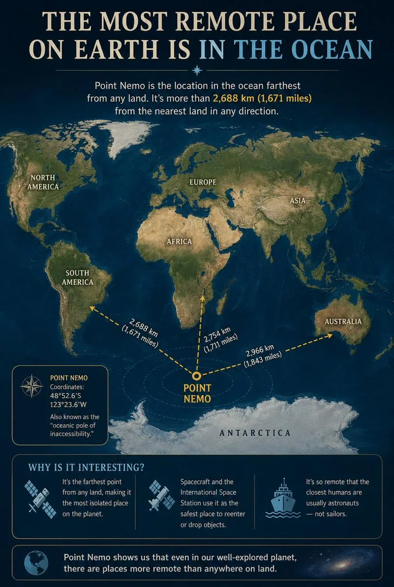
一張教育性信息圖,詳細介紹了尼莫點(Point Nemo),即海洋不可達極點,展示了其相對於各大洲的位置以及關於其偏遠程度的有趣事實。
提示詞
Goal: Create an educational infographic explaining {argument name="topic" default="Point Nemo, the most remote place on Earth located in the ocean"}.

Canvas: Vertical portrait layout with a deep navy blue background and a subtle starry night sky texture at the top. The style is clean, modern, and informative, using gold and white text for high contrast.

Layout:
1. **Header:** Large serif title "THE MOST REMOTE PLACE ON EARTH IS IN THE OCEAN" (with "IN THE OCEAN" highlighted in light blue). Below it, a small introductory paragraph defining Point Nemo as the location farthest from land, mentioning the distance of 2,688 km (1,671 miles).
2. **Central Map:** A stylized world map centered on the South Pacific Ocean. Continents are rendered in muted earth tones (greens, browns) against dark blue oceans. Labels include NORTH AMERICA, SOUTH AMERICA, EUROPE, ASIA, AFRICA, AUSTRALIA, and ANTARCTICA.
3. **Data Visualization:** A bright yellow dot marks "POINT NEMO" in the ocean south of Easter Island. Three dashed yellow arrows radiate from this point to the nearest landmasses, labeled with distances: "2,688 km (1,671 miles)" to Antarctica, "2,754 km (1,711 miles)" to South America, and "2,966 km (1,843 miles)" to Australia.
4. **Info Box (Left):** A rectangular box with a compass icon containing the coordinates "48°52.6'S 123°23.6'W" and the nickname "oceanic pole of inaccessibility."
5. **Bottom Section:** A section titled "WHY IS IT INTERESTING?" with three columns featuring icons and text:
   - Icon: Satellite dish. Text: "It's the farthest point from any land, making it the most isolated place on the planet."
   - Icon: Space station/satellite. Text: "Spacecraft and the International Space Station use it as the safest place to reenter or drop objects."
   - Icon: Ship. Text: "It's so remote that the closest humans are usually astronauts — not sailors."
6. **Footer:** A concluding statement next to a globe icon: "Point Nemo shows us that even in our well-explored planet, there are places more remote than anywhere on land."

Visual Style: Professional infographic design. Use clear sans-serif fonts for body text and serif fonts for headings. Ensure the map projection clearly highlights the isolation of the central point.
中文翻譯
目標:創建一張教育性信息圖,解釋 {argument name="topic" default="尼莫點,地球上位於海洋中的最偏遠地點"}。

畫布:垂直肖像佈局,採用深海軍藍背景,頂部帶有微妙的星空夜空紋理。風格簡潔、現代且信息豐富,使用金色和白色文字以確保高對比度。

佈局:
1. **標題:** 大號襯線字體標題 "THE MOST REMOTE PLACE ON EARTH IS IN THE OCEAN"(其中 "IN THE OCEAN" 以淺藍色高亮顯示)。下方是一個簡短的介紹段落,將尼莫點定義爲距離陸地最遠的位置,並提及距離爲 2,688 km (1,671 miles)。
2. **中心地圖:** 以南太平洋爲中心的風格化世界地圖。大陸以柔和的大地色調(綠色、棕色)渲染,與深藍色海洋形成對比。標籤包括 NORTH AMERICA, SOUTH AMERICA, EUROPE, ASIA, AFRICA, AUSTRALIA 和 ANTARCTICA。
3. **數據可視化:** 一個明亮的黃色圓點在復活節島南部的海洋中標記出 "POINT NEMO"。三條虛線黃色箭頭從該點輻射至最近的陸地,並標註了距離:到南極洲 "2,688 km (1,671 miles)",到南美洲 "2,754 km (1,711 miles)",到澳大利亞 "2,966 km (1,843 miles)"。
4. **信息框(左側):** 一個包含指南針圖標的矩形框,內含座標 "48°52.6'S 123°23.6'W" 和暱稱 "oceanic pole of inaccessibility"。
5. **底部部分:** 標題爲 "WHY IS IT INTERESTING?" 的部分,包含三列帶有圖標和文本的內容:
   - 圖標:衛星天線。文本:"它是距離任何陸地最遠的點,使其成爲地球上最孤立的地方。"
   - 圖標:空間站/衛星。文本:"航天器和國際空間站將其用作重新進入大氣層或投放物體的最安全地點。"
   - 圖標:船隻。文本:"它如此偏遠,以至於最近的人類通常是宇航員——而不是水手。"
6. **頁腳:** 地球圖標旁邊的結語:"尼莫點向我們展示,即使在我們探索充分的星球上,也有比陸地上任何地方都更偏遠的地方。"

視覺風格:專業信息圖設計。正文使用清晰的無襯線字體,標題使用襯線字體。確保地圖投影清晰地突出中心點的孤立性。
模板變數
該提示詞含可替換參數,方括號內為預設值
topic = Point Nemo, the most remote place on Earth located in the ocean
溯源
- 原作者
- Generated Atlas
- 發佈日期
- 2026-10-10
- 原始出處
- 查看原帖 ↗
- 收錄來源
- YouMind-OpenLab/awesome-gpt-image-2 · 36265 · CC-BY-4.0